Showing posts with label foldout of terrain. Show all posts

Saturday, May 14, 2016

The Photo Log, With an Additional Note on OSS CBI Photobook 15 - Southwest China, 1945- Reconnaissance, Part 5, Foldout of Terrain

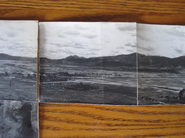
The panoramic view of the valley, preserved as a Foldout on Photobook Page 15,  has EJZ notations similar to those found in the Photo Log here in the Trove.


The Photo Log is a notebook 4" by 8", bound at the top, containing penciled notes relating three types of data: map design and map point numbering;  Roll and Negative Print numbers;  written descriptions of locations, persons, and events.  The cover is inscribed, "Picture Notes VOL. I" and "Eugene J. Zdrojewski F.P. with SO - Team Jackal."

"F.P." is Field Photo.
"SO" is Special Operations

The notes cover 5/31/1945 through 08/21/1945, and R1 through R11.

There is no mention of any R15, and no mention of J/Rnn.

The Foldout print notations are J/R15NP13 through J/R15NP22.

Does this mean that J is a parallel series of photos?   Where are the "Picture Notes" for J series photos?  Were they taken during that July?

Wednesday, April 8, 2015

OSS CBI Photobook 15 - Southwest China, 1945- Reconnaissance, Part 5, Foldout of Terrain

Previous posts concerning this page include:

A clutch of prints, taped together and folded up, were stuck somewhere in the Photobook.  Finally I figured out that they constituted a foldout from the top of Page 15.  Together they afford a wide-angle view of a certain valley, taken from pretty high up on one side.


Ten prints, roughly cut to 4x4 inches, have a total length of 41 inches.  I jumped up onto my desk to give you this overview.


Prints 1 and 2, by my numbering system, are glued into the book.  Presumably they are, by Dad's notation, J/R15NP13 and J/R15NP14.


Part of Print 2, all of 3, part of 4, below.  Print 3 has J/R15NP15 written on the back in his handwriting.


Prints 4 and 5, labeled J/R15NP16 and J/R15NP17, below.


Prints 6 and 7, labeled J/R15NP18 (presumably; the writing is obscured) and J/R15NP19, below:


Prints 8, 9, and 10, labeled J/R15NP20, J/R15NP21, (writing again obscured), and J/R15NP22, below.


Below are the same three, 8, 9, and 10, scanned.


Scan below of Prints 1 and 2, glued to Page 15:


Prints 3 and 4, below, with the village in its trees coming into view:


Prints 5 and 6, with the rest of the village at the left, and in the center a road that curves toward the village and then runs straight across the valley:


Prints 7 and 8 below, with another village consisting of several long buildings, and the first tufts of grass in the foreground:


Prints 9 and 10 complete the panorama:


One photo Record Book, at least, is in the Trove.  So far I have found records of other rolls, but not Roll 15.   The "J" is a mystery, but the rest surely means, for example, "Roll 15, Negative Print 20."


If I find an annotated record of Roll 15, we can learn precisely where this was.

Julie